


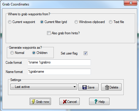
Tools=>Grab Coordinates, allows you to add waypoints to GSAK by scanning data for coordinate pairs. Click on any section in the picture below for more information on that item.
Warning: One of the main problems of grabbing coordinates from free floating text is being able to recognize the coordinate pairs. To the human eye this may seem obvious but trying to put this into code is something between "black art" and a nightmare. For this reason the coordinate grabber will never be perfect. It will miss some pairs that look valid, yet include others that are not. I have tried to put in "sanity" checking to avoid grabbing waypoints that don't make any sense, but it is not an exact science. However, the code for grabbing coordinates will evolve over time and hopefully get more accurate. If you do have a problem with a cache and it is obvious it can be easily fixed by changing the source data, then I suggest you contact the cache owner to make the necessary changes - that way all GSAK users (and other coordinate grabbing tools) will benefit.
When generating the waypoints into the GSAK database you need to configure how you would like the waypoint code and name to be generated.
The shipped defaults are only suggested and you can try with other combinations of special tags to suit you needs. All waypoints grabbed have the source type set to "GW" (Grabbed Waypoint) ,so at any time you can set a filter on this source type to get a subset of any grabbed waypoints (a good way to quickly delete them if you need to)
When grabbing from the clipboard, duplicate waypoints (those having the same lat, lon are ignored). When grabbing from the database waypoints with the same lat, lon for the same cache are ignored (not the whole filter). GSAK will also "remember" the waypoints grabbed from each cache and will not duplicate if you run the grab again.
There are two new tags you can use which only apply to this dialog:
%GrabNo - This special tag must always be used somewhere in the code. GSAK will allocate a number to this variable and will keep incrementing this number should the resulting code already exist in the database somewhere (code collision protection)
%GrabName - This special tag can be used to give a meaningful name to the waypoint. This really is a black art, but GSAK interrogates the preceding text of the found waypoint and tries to come up with some sort of meaningful description. This description is then substituted for the %GrabName tag. It is far from perfect and the algorithm will evolve over time.
If you have the split screen active or generate HTML you will also notice the description of the Cache shows you the waypoint code and name it was grabbed from, and the context where the waypoint was found. The context (another black art) tries to isolate the salient information of the grabbed waypoint (from the surrounding text). This is another item that will evolve over time, but because of the varying formats of the cache descriptions I suspect it will be impossible to *get it right*
You can also generate waypoints from text copied to the clipboard. So if you see some text in your browser you would like to grab some waypoints from, just highlight the text, copy it, then select this option in the grabber. However, please note that this option is not as "accurate" as plucking waypoints from the description of a cache in your database. The main reason being that waypoints grabbed from your database have a certain amount of "sanity" checking to make sure the generated waypoints have a consistent relationship with the grabbed cache. This can not be done when grabbing information from the clipboard so you may get some "funny" looking waypoints added. You are also prevented from using most of the special tags on this option, because most special tags only apply to the current cache and when using the clipboard there is no "current cache"
If you have a file that is "free floating text" then open the file in your text editor and copy the contents to the clipboard - you can then use the clipboard option to grab waypoints.
The GRAB command is also supported in the macro language to grab coordinates under macro control
Note: Text file grab is now deprecated. If you want to load a CSV file into GSAK then "File=>Load=>GPX" and selecting the file type of "Text (with first line field structure)" is more flexible and allows you to load more data. However, to maintain backwards compatibility, this feature is still enabled.
Text file grab - The file option is slightly different in the sense that your text file must be structured. I have tried to keep this one simple and I am hoping this will cater for the majority of cases where you just want to get this type of file into GSAK as waypoints. GSAK supports CSV and tab delimited text files (automatically detected) and you can map which columns correspond to lat, lon, and waypoint name. The format for lat and lon is quite flexible and the following would all be valid for the same waypoint:
N 35° 49.385, W 086° 50.438
35°49'23.10" N, 86°50'26.28" W
35°49.38498, -86°50.437979
35d 49.38498m N, -86d 50.437979m W
35.823083, -86.840633
N35.823083, W86.840633