


This dialog enables you to "project" a waypoint from another point.
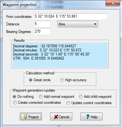
Coordinates - Enter the coordinates of your starting point. The coordinates of your currently selected cache in the grid are automatically input here when you take this option. However, you can change the coordinates to anything you like.
Distance - The distance from your starting point. Available measurements are Miles, Nautical miles, kilometers, meters, yards, feet.
Bearing - The true north bearing in degrees.
Results - When you click on the "Project" button, the projected waypoint will show in this box in various formats.
Calculation Method - The most common formula for the calculation of distance and bearing between 2 points is the "Great circle" method. However, as this method does assume the Earth is a perfect sphere (where as it is more an ellipsoid), small errors can creep in over long distances. The "High accuracy" method uses "Vincenty's algorithm" for this calculation. For most calculations "Great circle" is just fine, but some Puzzle caches require the use of "High accuracy" and hence the reason for providing this option.
Waypoint Generation - Optionally, you can also have the projected coordinate automatically added as a normal waypoint, child waypoint Waypoint, Corrected coordinate, or update the coordinates for the current waypoint.